By Andrew Stevenson
The Outer Hebrides lie off the north-west coast of mainland Scotland, approximately between 56º N and 58º N latitudes. The main islands of Lewis & Harris, Berneray, North Uist, Grimsay, Benbecula, South Uist, Eriskay, Barra and Vatersay form a chain over 100 miles long. To the south beyond Vatersay is a chain of uninhabited islands stretching down to Berneray or Barra Head the southernmost island. Outwith this main chain are the remote outlying islands, the Monach or Heisker (5 miles west of North Uist), the Shiants (5 miles east of Lewis), the Flannans (16 west of Lewis), North Rona & Sula Sgeir and St. Kilda. The latter groups are some of the most remote islands in the UK, with North Rona & Sula Sgeir lying 40 miles north of the Butt of Lewis and St. Kilda 40 miles west of North Uist.
The Outer Hebrides are separated from the Scottish mainland by the stretches of water known as the Minch, Little Minch, and the Sea of the Hebrides. The Minch being north of Skye, the Little Minch between Skye and the Uists, and the Sea of the Hebrides between Barra and Argyll.
Geology & Geomorphology
The islands are largely composed of Lewisian gneiss, with some volcanic rocks, basalt and gabbro, and sandstone. The sandstone is limited to parts of the Point district of Lewis and the Shiant islands, with the volcanic rocks largely associated with some of the outlying islands such as St Kilda. Lewisian gneiss which forms the bulk of the main island chain, is a metamorphic rock similar to granite, but in many areas less acidic in nature. It is a hard rock leading to some dramatic craggy hills, particularly in Harris. The soils are generally poor compared to the mainland with glacial boulder clay overlain by peat of varying thickness. Where there is low lying coast a dry light sandy soil is found formed by shell sand blowing inland on to the peat. This is most extensive along the west coast of the island chain. The islands also have a ‘drowned’ coastline i.e. the land was flooded after sea levels rose following the end of glaciation. This has resulted in many sea lochs and some very intricate coastline mainly along the rockier east coast. Glaciation also scoured out a large number of hollows resulting in a large number of freshwater lochs of varying sizes, over 2000 in fact.
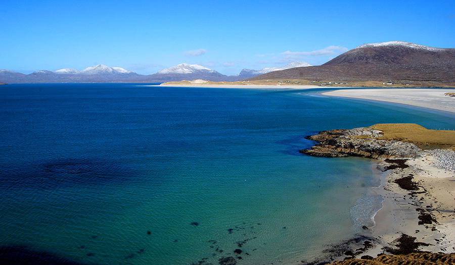
Luskentyre © Hebridean Imaging
Climate
Lying off the north-west coast of Scotland, on the edge of the North Atlantic drift it is no surprise that the islands have a largely temperate, oceanic climate, with less snow and frost than adjacent areas of mainland Scotland. The average winter temperature is 4-5 ºC whilst in summer it ranges between 13-15ºC. The prevailing winds are largely from the western half of the compass and bring in fronts from the Atlantic. This results in an average rainfall of around 125cm per year. The wind itself is also a feature with very few days of the year with calm conditions, and particularly between autumn and spring there are frequent gales and storms. In some severe storms winds have reached over 100knots/hr.
Landscape
The landscape of the Outer Hebrides is very varied, and the character of each the main islands are different. The effects of exposure and the islands location makes for an open relatively treeless environment. Much of Lewis is characterised by low hills and open rolling peatland littered with freshwater lochs and lochans. The areas of settlement and agriculture are largely dotted around the coast on the more fertile land, and sheltered harbours. Much of Lewis lies below 200m above sea level, but the south and south west of the island have hills rising to over 500m.
Harris which is joined to Lewis has some of the most dramatic scenery in the Outer Hebrides, due to the combination of the rocky glaciated hills juxtaposed with sealochs, intertidal inlets and islands. The north Harris hills form the largest area of upland in the islands with several hills rising above 600m, culminating in the Clisham at 799m, the highest hill in the Outer Hebrides. The sandy coastline along the west coast of south Harris, is backed by lower hills dotted with lochans. The Sound of Harris between Harris and Uist is a rather shallow stretch of sea full of sandbanks and skerries, and the ferry route weaves its way past a plethora of picturesque islands.
North Uist has largely sandy coastlines around its north and west coasts giving rise to extensive sand dunes and inter tidal islands, whilst its east coast is rocky with sealochs and inlets. Inland of the sandy coastline are large area of agricultural land with scattered settlements. The centre and east of the island, are characterised by largely low, rolling hills, the highest being Eaval at 347m, and peatland with an intricate maze of freshwater lochs and lochans. Much of North Uist lies below 100m above sea level.
Benbecula is linked to North Uist and South Uist by large intertidal fords, and is very low lying, much of it under 50m above sea level. The eastern half of the island is again peatland dissected by freshwater lochs and sealochs. In the centre of the island is Rueval a dominant hill rising to124m. The west side of the island is largely open sandy coastline with agricultural land inland and contains most of the settlement.
South Uist has a large strip of sandy coastline with agricultural land running the length of its west coast, which contrasts with the rocky east coast with its sealochs, and central strip of peatland and hills. The central South Uist hills are the highest in Uist & Barra rising to 620m with Beinn Mhor. Both the peatland and the western plain contain an array of freshwater lochs. Most settlement is along the western side of the island except for those around harbours.
The Sound of Barra is similar in some ways to the Sound of Harris with its mix of islands and skerries.
Barra is quite a rocky island with the central hilly moorland area rising to 383m with Heaval. Most of the agricultural land is around the coast and on the sandy north end of the island, as is the settlement.
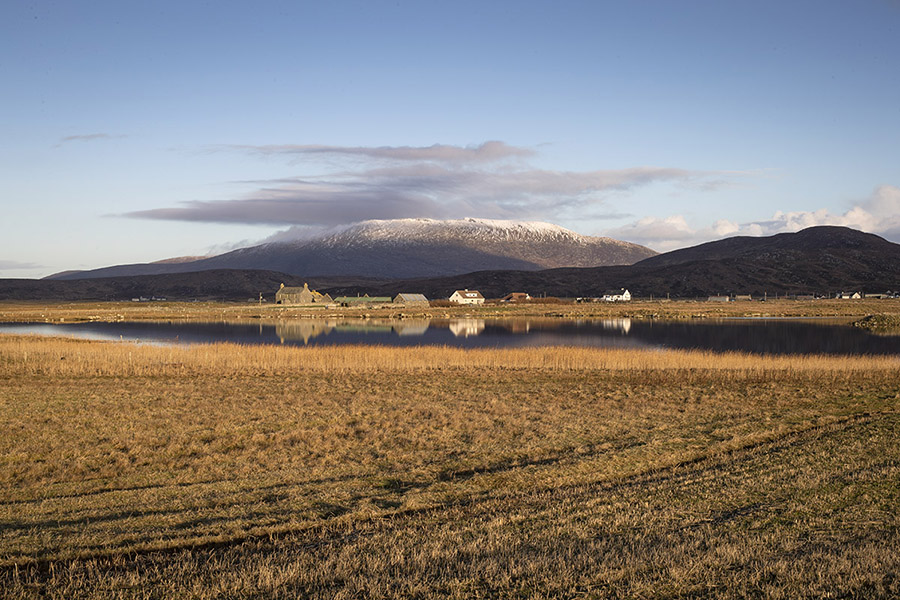
View over Milton to Ben Mhor, South Uist © Hebridean Imaging
Habitats
The varied habitats of the Outer Hebrides support a wide range of breeding, migrant and wintering birds, a number of which occur in nationally or internationally important concentrations in conservation terms.
Outlying Island Groups
The outlying islands of St. Kilda, North Rona & Sula Sgeir, Flannans, Monach Islands, Shiant Islands and the uninhabited islands south of Vatersay, especially Mingulay and Barra Head provide a range of coastal habitats including some of the highest and most dramatic sea cliffs in the UK. The Monach Islands being the exception, as they are low lying islands with sand dunes and rocky reefs. Individually and collectively these island groups hold nationally and internationally important concentrations of seabirds, such as gannets, fulmar, Manx shearwater, Leach’s and storm petrels, all the UK breeding auks, cormorant, shag, great skua, great black-backed gull and kittiwake. They also have a variety of breeding waders, terns and some wildfowl, whilst St Kilda has its own race of wren.
Inshore Waters
The inshore waters around the islands support a range of seabirds and waterfowl. In the breeding season these waters provide important feeding areas for seabirds such as Arctic, common and little terns; black guillemots, puffins and other auks; various gulls, Arctic and great skuas and gannets. They also support other breeding waterfowl such as red-throated divers, cormorants, shags, eiders and red-breasted mergansers. During winter and migration periods these areas are home to nationally or regionally important additional species like great northern and black-throated divers; long-tailed ducks, common scoters, and slavonian grebes.
Inshore Islands & Skerries
The islands in the larger Sounds and sealochs provide breeding sites for a wide range of birds, including regionally important numbers of Arctic and common terns, cormorants, grey herons, eider, greylag geese, fulmar, and various gulls in addition to other species such as Arctic skua, raven, buzzard, and waders like ringed plover and oystercatcher. In winter some of these islands support flocks of barnacle geese as well as a range of waders.
Rocky Coasts and Cliffs
Around the coasts of the main islands the rocky or cliffed coast supports smaller numbers of the same seabird species as found on the offshore islands, but also herons, eiders, red-breasted mergansers, rock doves, rock pipits and raptors such as peregrine, kestrel, buzzard, and golden eagle.
Sealochs, Lagoons (Brackish Lochs) and Intertidal Areas
These areas support a similar range of waterbirds to the coastal habitats mentioned above but additionally have a wider range of wildfowl and waders in both summer and winter. Numbers of birds in most sealochs are generally small by comparison to the larger intertidal areas but support mallard, teal, wigeon, redshank, curlew, turnstone, oystercatcher, greenshank and shelduck amongst others. The lagoons are more of a Uist feature and are notable for supporting large numbers of mute swans, wigeon, teal, and little grebes in winter. The large areas of intertidal mud and sand regularly support a wide range of waders often in nationally or internationally important numbers such as ringed plover, dunlin, grey plover, bar-tailed godwit, sanderling, turnstone, redshank and purple sandpiper. The large areas of seaweed found on many shorelines especially in Uist provides feeding for some of these waders and also for a range of gulls which in winter often include glaucous and Iceland.
Machair and Agricultural Land
Machair is a term used to describe the low lying sandy plain inland of the soft sand dune coast. It is most well developed in the Uists and south Harris and has traditionally been used for grazing and arable agriculture. The agricultural land extends a bit further inland on to better soils at the edge of the moorland. This mix of sand dunes, wet and dry grassland studded with lochs and marshes combined with agricultural uses supports a rich mix of breeding birds. Again, this includes several species of international, national or regional importance like corncrake, dunlin, ringed plover, redshank, snipe, red-necked phalarope, corn bunting, and a variety of wildfowl including wigeon, gadwall, shoveler and high densities of mute swan. In winter the machair is often wet with seasonally flooded areas and attracts flocks of waders including large numbers of curlew, golden plover and lapwing. Wildfowl, like greylag, white-fronted and barnacle geese, and nationally important numbers of whooper swans occur with a range of duck found on the lochs. Also, the arable stubble areas provide feeding for a range of birds including snow and lapland buntings, skylarks, starlings, rock doves and twite. With such a range of birds around hunting raptors occur regularly including buzzard, hen harrier, merlin and peregrine.
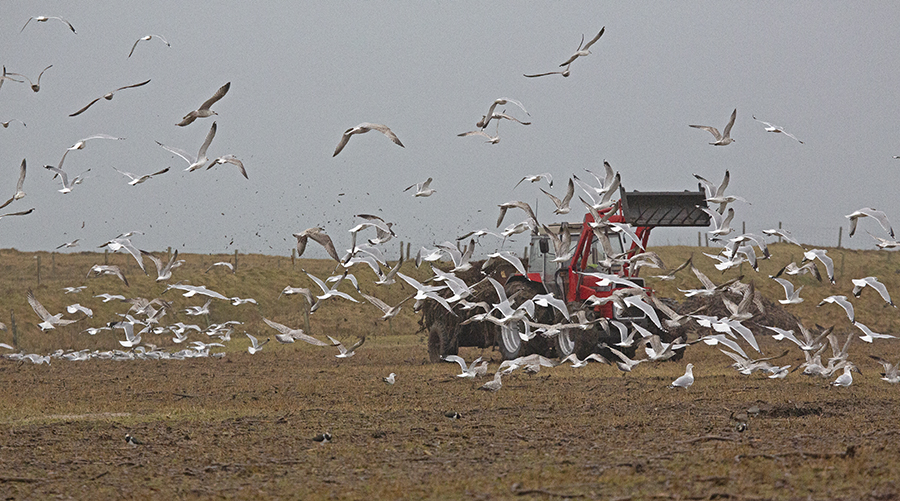
Gulls on the machair © Hebridean Imaging
Moorland, Peatland and Upland
These habitats, especially the watery moors and peatland are like much of the rest of the islands internationally, nationally, or regionally important for their breeding birds. The species found here include high densities of golden plover, dunlin, greenshank, whimbrel, curlew, red-throated and black-throated divers, merlin, hen harrier, peregrine, golden eagle, short-eared owl, Arctic skua, great skua, greylag goose, red-breasted merganser, teal, wigeon and twite. Also out on the moors and hills can be found the Hebridean races of wren, dunnock and song thrush.
Woodland & Scrub
There is little in the way of native woodland or scrub to be found on the islands except in sheltered glens and gullies and on islands in lochs away from the grazing effects of deer and sheep. It is largely willow, rowan, birch and aspen and provides breeding sites for a number of species such as wren, dunnock, robin, willow warbler and stonechat. There are, however, areas of non-native woodland and scrub, the most notable being Stornoway Woods. However, within the last 20 years or so there have been more coniferous plantations and shelterbelts put in along with an increasing interest in re-creating semi-native woodland. This general lack of woodland means that many of the species typical of woods and gardens on the mainland are rare or restricted in their distribution. The Stornoway area for example holds the only rookeries in the Outer Hebrides and Stornoway Woods hold the majority or indeed the entirety of breeding blue and coal tits, treecreeper, and warblers excepting willow and sedge. It also has breeding records for bullfinch, tree sparrow, goldfinch, and siskin.
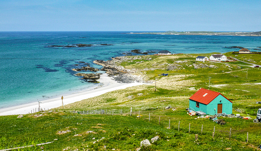
Eriskay © Hebridean Imaging